


Feldlahn-Alm Runde
Familienfreundliche, kinderwagentaugliche, leichte Almwanderung zur bewirteten Feldlahn-Alm - einer der Achentaler Familientipps

Distanz
Dauer
Höchster Punkt
Höhenmeter aufwärts
Höhenmeter abwärts
Almwanderung
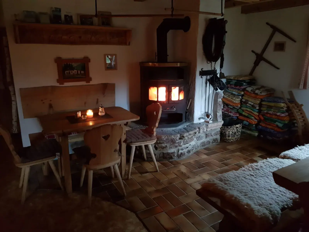
Einkehrmöglichkeiten: Feldlahn-Alm, Poststüberl Oberwössen, Brotzeitherzhafte Zwischenmahlzeit (z. B. Brot, Speck, Käse)-Meinecke Oberwössen; (*) (bitte individuelle Öffnungszeiten beachten)
Achental Wandernadel Kontrollstellen: Feldlahnalm
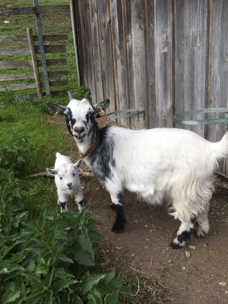
Besonderheiten: “hauseigener Streichelzoo” mit Eseln und Ziegen – besonders für die kleinen Besucher ein motivierender Ansporn; kinderwagentaugliche Tour;
Tipp: Auch an schneefreien Wintertagen ist die Wanderung zur Feldlahn-Alm empfehlenswert. Auf der Alm kann ganzjährig gemütlich eingekehrt werden.
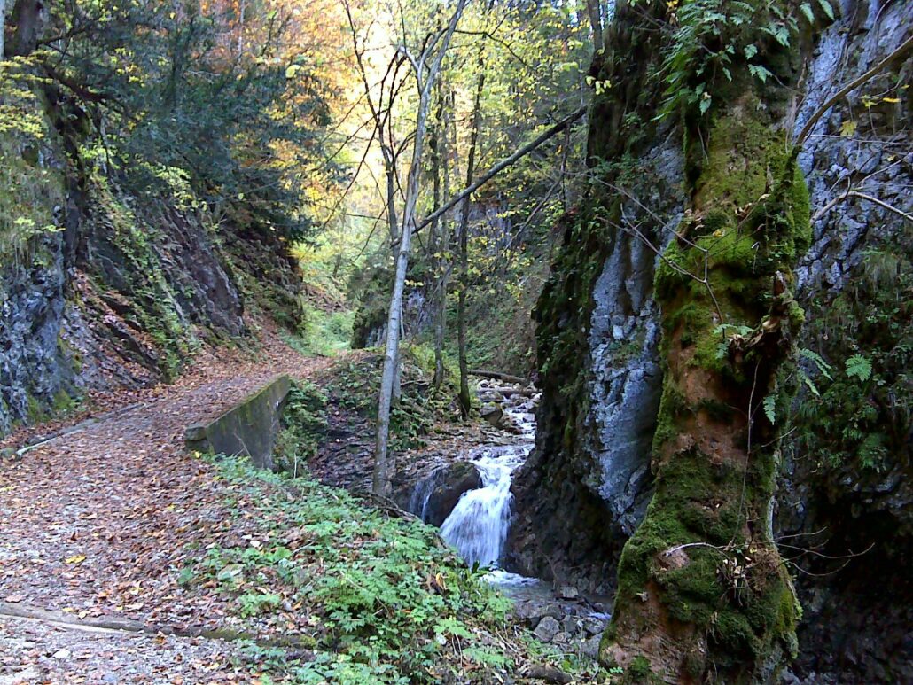
Beschreibung: Oberwössen – Wanderparkplatz Hammerergraben – Feldlahn-Alm – Hammererbach Schlucht – Wanderparkplatz Hammerergraben;
Vom Ausgangspunkt, dem Wanderparkplatz Hammergraben in Oberwössen führen zwei Wegvarianten auf die 955m hoch gelegene Feldlahn-Alm. Die kinderwagentaugliche Variante führt auf der Forststraße (Weg Nr. 75; Aufstiegdauer: ca. 1 1/2 Stunden) und die zweite, nicht-kinderwagentaugiche Variante führt entlang des Hammersbachs durch eine waldreiche Schlucht mit vielen kleinen Wasserfällen. Die beschauliche Alm liegt geschützt in einer idyllischen Senke. Am Ziel angelangt können die kleinen Abenteurer den “hauseigenen Streichelzoo”, mit Eseln und Ziegen weiter erkunden. Während die kleinen Wanderer viel Freude mit den Tieren haben, kann die almtypische Brotzeit genossen werden – bestehend aus frisch zubereiteten kräftigen Käs- und Speckbretteln oder auch Suppen mit Knödeln oder Pfannkuchen. Frisch gestärkt kann nun der Rückweg angetreten werden, welcher (bei Mitnahme eines Kinderwagens) auf dem Aufstiegsweg erfolgt. Alternativ kann ebenfalls der Weg über die Forststraße oder der bereits bekannte Aufstiegsweg gewählt werden.


 https://www.achental.com/storage/2024/08/53357_DSC00015.jpg
1440
1920
admin
https://www.achental.com/storage/2022/07/achental-logo-weiss-horizontal-RGB@2x.png
admin2026-07-15 04:31:042026-08-02 05:30:59Taubensee über Luftboden- u. Kroatensteig
https://www.achental.com/storage/2024/08/53357_DSC00015.jpg
1440
1920
admin
https://www.achental.com/storage/2022/07/achental-logo-weiss-horizontal-RGB@2x.png
admin2026-07-15 04:31:042026-08-02 05:30:59Taubensee über Luftboden- u. Kroatensteig https://www.achental.com/storage/2026/06/DcHtGxyUvWs9nqkakIGPSBPtCfgD3LOi35aMnv1y.jpg
1920
1080
admin
https://www.achental.com/storage/2022/07/achental-logo-weiss-horizontal-RGB@2x.png
admin2026-07-14 04:31:242026-08-02 06:19:48Rundwanderung zur Bäcker Alm über Hutschen Steig und Streichenkirche
https://www.achental.com/storage/2026/06/DcHtGxyUvWs9nqkakIGPSBPtCfgD3LOi35aMnv1y.jpg
1920
1080
admin
https://www.achental.com/storage/2022/07/achental-logo-weiss-horizontal-RGB@2x.png
admin2026-07-14 04:31:242026-08-02 06:19:48Rundwanderung zur Bäcker Alm über Hutschen Steig und Streichenkirche https://www.achental.com/storage/2024/08/89475_Fliegerstadl.jpg
1200
1600
admin
https://www.achental.com/storage/2022/07/achental-logo-weiss-horizontal-RGB@2x.png
admin2026-06-29 10:00:272026-08-02 05:51:31Rund um den Segelflugplatz
https://www.achental.com/storage/2024/08/89475_Fliegerstadl.jpg
1200
1600
admin
https://www.achental.com/storage/2022/07/achental-logo-weiss-horizontal-RGB@2x.png
admin2026-06-29 10:00:272026-08-02 05:51:31Rund um den Segelflugplatz https://www.achental.com/storage/2024/09/74094_chiemhauser_alm.jpg
683
1024
admin
https://www.achental.com/storage/2022/07/achental-logo-weiss-horizontal-RGB@2x.png
admin2026-06-10 15:20:042026-08-02 05:50:19Chiemhauser Alm
https://www.achental.com/storage/2024/09/74094_chiemhauser_alm.jpg
683
1024
admin
https://www.achental.com/storage/2022/07/achental-logo-weiss-horizontal-RGB@2x.png
admin2026-06-10 15:20:042026-08-02 05:50:19Chiemhauser Alm https://www.achental.com/storage/2024/08/26zYufdX4NMxLFSUAZU6qgctpZzeNaWddb48hxEO.jpg
1200
1600
admin
https://www.achental.com/storage/2022/07/achental-logo-weiss-horizontal-RGB@2x.png
admin2026-06-01 04:30:422026-08-02 05:30:55Schleching – Taubensee – Kössen
https://www.achental.com/storage/2024/08/26zYufdX4NMxLFSUAZU6qgctpZzeNaWddb48hxEO.jpg
1200
1600
admin
https://www.achental.com/storage/2022/07/achental-logo-weiss-horizontal-RGB@2x.png
admin2026-06-01 04:30:422026-08-02 05:30:55Schleching – Taubensee – Kössen https://www.achental.com/storage/2024/08/pejbmfCCGu4pWhIVHdwYPqxcr3MNRGeXG0ybNtIc.jpeg
1920
1440
admin
https://www.achental.com/storage/2022/07/achental-logo-weiss-horizontal-RGB@2x.png
admin2026-04-01 04:30:512026-08-02 05:34:02Großer Moorrundweg
https://www.achental.com/storage/2024/08/pejbmfCCGu4pWhIVHdwYPqxcr3MNRGeXG0ybNtIc.jpeg
1920
1440
admin
https://www.achental.com/storage/2022/07/achental-logo-weiss-horizontal-RGB@2x.png
admin2026-04-01 04:30:512026-08-02 05:34:02Großer Moorrundweg https://www.achental.com/storage/2024/08/55274_blick_in_die_berge_2_pl-scaled.jpg
1280
1920
admin
https://www.achental.com/storage/2022/07/achental-logo-weiss-horizontal-RGB@2x.png
admin2026-04-01 04:30:492026-08-02 05:31:07Kleiner Moorrundweg
https://www.achental.com/storage/2024/08/55274_blick_in_die_berge_2_pl-scaled.jpg
1280
1920
admin
https://www.achental.com/storage/2022/07/achental-logo-weiss-horizontal-RGB@2x.png
admin2026-04-01 04:30:492026-08-02 05:31:07Kleiner Moorrundweg https://www.achental.com/storage/2024/09/WZJlqIkVEuccA8p1fsOjMJSb0cxuH9tFgfrD2FDq.jpg
160
240
admin
https://www.achental.com/storage/2022/07/achental-logo-weiss-horizontal-RGB@2x.png
admin2026-03-12 04:31:002026-08-02 05:34:26Geigelsteinparkplatz – Breitenstein übers Karl – Walchsee
https://www.achental.com/storage/2024/09/WZJlqIkVEuccA8p1fsOjMJSb0cxuH9tFgfrD2FDq.jpg
160
240
admin
https://www.achental.com/storage/2022/07/achental-logo-weiss-horizontal-RGB@2x.png
admin2026-03-12 04:31:002026-08-02 05:34:26Geigelsteinparkplatz – Breitenstein übers Karl – Walchsee https://www.achental.com/storage/2024/12/LcejznXvo6xVyvNvxNL6JugyMICDsfQNecdq6Ovs-scaled.jpg
1440
1920
admin
https://www.achental.com/storage/2022/07/achental-logo-weiss-horizontal-RGB@2x.png
admin2026-01-27 04:30:302026-08-02 06:14:17Schlechinger Krippen-, Kirchen- und Kapellenweg
https://www.achental.com/storage/2024/12/LcejznXvo6xVyvNvxNL6JugyMICDsfQNecdq6Ovs-scaled.jpg
1440
1920
admin
https://www.achental.com/storage/2022/07/achental-logo-weiss-horizontal-RGB@2x.png
admin2026-01-27 04:30:302026-08-02 06:14:17Schlechinger Krippen-, Kirchen- und Kapellenweg https://www.achental.com/storage/2024/08/89715_IMG_6554.jpg
667
1000
admin
https://www.achental.com/storage/2022/07/achental-logo-weiss-horizontal-RGB@2x.png
admin2025-09-23 10:17:352026-08-02 05:54:02SalzAlpenSteig – Brachtalm – Bergen
https://www.achental.com/storage/2024/08/89715_IMG_6554.jpg
667
1000
admin
https://www.achental.com/storage/2022/07/achental-logo-weiss-horizontal-RGB@2x.png
admin2025-09-23 10:17:352026-08-02 05:54:02SalzAlpenSteig – Brachtalm – Bergen https://www.achental.com/storage/2024/08/b8iOrMdXDH2iRRzzzlFDQdO3WAtoGzvqAQKML4ax-scaled.jpg
1280
1920
admin
https://www.achental.com/storage/2022/07/achental-logo-weiss-horizontal-RGB@2x.png
admin2025-08-21 01:03:332026-08-02 05:35:08Kaiserblick
https://www.achental.com/storage/2024/08/b8iOrMdXDH2iRRzzzlFDQdO3WAtoGzvqAQKML4ax-scaled.jpg
1280
1920
admin
https://www.achental.com/storage/2022/07/achental-logo-weiss-horizontal-RGB@2x.png
admin2025-08-21 01:03:332026-08-02 05:35:08Kaiserblick https://www.achental.com/storage/2024/08/U3BrAJ0PL6ElYOY3ZdIlTL2rEqwwCGWqgHu9PJ5x-scaled.jpg
1280
1920
admin
https://www.achental.com/storage/2022/07/achental-logo-weiss-horizontal-RGB@2x.png
admin2025-08-21 01:03:332026-08-02 05:59:48Kaiserblick über Hofkapelle und Süssen
https://www.achental.com/storage/2024/08/U3BrAJ0PL6ElYOY3ZdIlTL2rEqwwCGWqgHu9PJ5x-scaled.jpg
1280
1920
admin
https://www.achental.com/storage/2022/07/achental-logo-weiss-horizontal-RGB@2x.png
admin2025-08-21 01:03:332026-08-02 05:59:48Kaiserblick über Hofkapelle und Süssen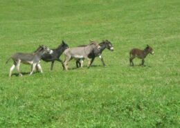 https://www.achental.com/storage/2024/09/58286_Eselgruppe_Feldlahnalm-scaled.jpg
1440
1920
admin
https://www.achental.com/storage/2022/07/achental-logo-weiss-horizontal-RGB@2x.png
admin2025-08-11 01:05:512026-08-02 05:50:25Feldlahn-Alm Runde
https://www.achental.com/storage/2024/09/58286_Eselgruppe_Feldlahnalm-scaled.jpg
1440
1920
admin
https://www.achental.com/storage/2022/07/achental-logo-weiss-horizontal-RGB@2x.png
admin2025-08-11 01:05:512026-08-02 05:50:25Feldlahn-Alm Runde https://www.achental.com/storage/2024/08/uAXwsoY3UYI9OGZhtcYSGQcm8ZSeNVffconHhfsx.jpg
1000
1500
admin
https://www.achental.com/storage/2022/07/achental-logo-weiss-horizontal-RGB@2x.png
admin2025-06-30 01:04:062026-08-02 05:31:22Kneipp-Rundweg
https://www.achental.com/storage/2024/08/uAXwsoY3UYI9OGZhtcYSGQcm8ZSeNVffconHhfsx.jpg
1000
1500
admin
https://www.achental.com/storage/2022/07/achental-logo-weiss-horizontal-RGB@2x.png
admin2025-06-30 01:04:062026-08-02 05:31:22Kneipp-Rundweg https://www.achental.com/storage/2025/04/nV476nrT9mvyHOa7MYY0bXVDdvYmGLPytpHjhkD5.jpg
1600
1200
admin
https://www.achental.com/storage/2022/07/achental-logo-weiss-horizontal-RGB@2x.png
admin2025-06-03 13:34:432026-08-02 06:15:17Wanderbus Tour – Von Unterwössen über Agersgschwendt-Alm, das Hochgernhaus und die Staudacher-Alm nach Staudach-Egerndach
https://www.achental.com/storage/2025/04/nV476nrT9mvyHOa7MYY0bXVDdvYmGLPytpHjhkD5.jpg
1600
1200
admin
https://www.achental.com/storage/2022/07/achental-logo-weiss-horizontal-RGB@2x.png
admin2025-06-03 13:34:432026-08-02 06:15:17Wanderbus Tour – Von Unterwössen über Agersgschwendt-Alm, das Hochgernhaus und die Staudacher-Alm nach Staudach-Egerndach https://www.achental.com/storage/2024/08/u2HwesK0YOAlwekbh9PZO1vtmYPpcOnerulf3hgO-scaled.jpg
1280
1920
admin
https://www.achental.com/storage/2022/07/achental-logo-weiss-horizontal-RGB@2x.png
admin2025-04-30 09:22:232026-08-02 06:15:10Wanderbus Tour – Von Schleching-Mühlau über Oberauerbrunstalm und Staffn-Alm zur Talstation Hochplattenbahn
https://www.achental.com/storage/2024/08/u2HwesK0YOAlwekbh9PZO1vtmYPpcOnerulf3hgO-scaled.jpg
1280
1920
admin
https://www.achental.com/storage/2022/07/achental-logo-weiss-horizontal-RGB@2x.png
admin2025-04-30 09:22:232026-08-02 06:15:10Wanderbus Tour – Von Schleching-Mühlau über Oberauerbrunstalm und Staffn-Alm zur Talstation Hochplattenbahn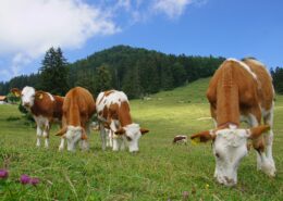 https://www.achental.com/storage/2024/08/51253_DSC00673_1920x1278.jpg
1278
1920
admin
https://www.achental.com/storage/2022/07/achental-logo-weiss-horizontal-RGB@2x.png
admin2025-04-30 09:21:342026-08-02 05:43:47Rundweg über die Grassauer Almen
https://www.achental.com/storage/2024/08/51253_DSC00673_1920x1278.jpg
1278
1920
admin
https://www.achental.com/storage/2022/07/achental-logo-weiss-horizontal-RGB@2x.png
admin2025-04-30 09:21:342026-08-02 05:43:47Rundweg über die Grassauer Almen https://www.achental.com/storage/2025/04/qpvmmdv49hl3yLq7YUmePgDvGu0440jyq5EF14aZ.jpg
1280
1920
admin
https://www.achental.com/storage/2022/07/achental-logo-weiss-horizontal-RGB@2x.png
admin2025-04-24 05:00:212026-08-02 06:15:23Wanderbus Tour – Von Hinterwössen über die Chiemhauser- und Baumgartner Alm zum Streichen Parkplatz
https://www.achental.com/storage/2025/04/qpvmmdv49hl3yLq7YUmePgDvGu0440jyq5EF14aZ.jpg
1280
1920
admin
https://www.achental.com/storage/2022/07/achental-logo-weiss-horizontal-RGB@2x.png
admin2025-04-24 05:00:212026-08-02 06:15:23Wanderbus Tour – Von Hinterwössen über die Chiemhauser- und Baumgartner Alm zum Streichen Parkplatz https://www.achental.com/storage/2025/04/R2NrdsxP0KrRNncszj3UXFYtJNaRR5Yf3VJs6eOi.jpg
1920
1080
admin
https://www.achental.com/storage/2022/07/achental-logo-weiss-horizontal-RGB@2x.png
admin2025-04-24 05:00:212026-08-02 06:15:29Wanderbus Tour – Schmugglerweg von Ortsmitte Schleching nach Kössen
https://www.achental.com/storage/2025/04/R2NrdsxP0KrRNncszj3UXFYtJNaRR5Yf3VJs6eOi.jpg
1920
1080
admin
https://www.achental.com/storage/2022/07/achental-logo-weiss-horizontal-RGB@2x.png
admin2025-04-24 05:00:212026-08-02 06:15:29Wanderbus Tour – Schmugglerweg von Ortsmitte Schleching nach Kössen https://www.achental.com/storage/2024/08/OqqtL2ddEOAljbylKsbGYuTNgwTs5VV03aCmQVk7-scaled.jpg
1280
1920
admin
https://www.achental.com/storage/2022/07/achental-logo-weiss-horizontal-RGB@2x.png
admin2025-04-24 01:08:072026-08-02 05:39:53Schmugglerweg nach Kössen
https://www.achental.com/storage/2024/08/OqqtL2ddEOAljbylKsbGYuTNgwTs5VV03aCmQVk7-scaled.jpg
1280
1920
admin
https://www.achental.com/storage/2022/07/achental-logo-weiss-horizontal-RGB@2x.png
admin2025-04-24 01:08:072026-08-02 05:39:53Schmugglerweg nach Kössen

 Kaiserblick

 canva
canva 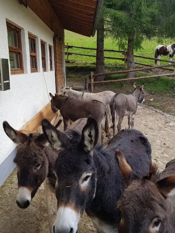